
What Does It All Mean?
In Hill Country, we hear a lot about aquifers and recharge, and occasionally karst. What do these terms mean, how do they relate to each other, and why are they important?
Karst refers to the landscape characterized by the dissolution of soluble rocks (e.g., limestone, dolomite, or gypsum) by slightly acidic water. Some features of karst landscapes include sinking streams, springs, sinkholes, and caves. The process that forms these begins with rainwater. Rainwater picks up small amounts of CO2 from the air, and even more from decaying plant and animal matter in the soil, becoming carbonic acid. This weak acid travels through the soil, then through cracks and pores in the bedrock, slowly dissolving the rock, while making the cracks and pores larger. This process continues for thousands of years.
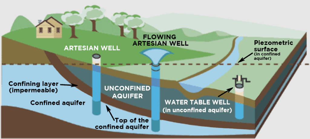
As the water continues downward, it reaches an area where all the pores, cracks, and other spaces are full of water. Think about digging a hole in the sand at the beach. Dig far enough and the hole will partially fill with water. The upper surface is called the water table (at the beach, this would be sea level) and the area beneath the water table is the aquifer.
An aquifer is a natural reservoir of underground water held within porous rock that can deliver water in usable quantities. In other words, you can dig a well and pump water out of it. In karst areas, large aquifers can form.
The Edwards Aquifer, named after the Edwards rock formation, is the source of water in our area. These rocks formed more than 100 million years ago when Central Texas was covered by a shallow sea. Limestone formed in this shallow sea from the accumulation of shells and skeletons of marine animals, which were compacted and cemented together over time. The main mineral in limestone is calcite (calcium carbonate), which dissolves in carbonic acid. This created an enormous area underground for water storage.
The Edwards Aquifer is huge—the surface area above the aquifer covers about 3,600 square miles.
Aquifers provide many people with drinking water, but also provide water for industrial and agricultural uses.
Aquifers have contributing, recharge and artesian zones. The contributing zone of the Edwards Aquifer is mostly on the Edwards Plateau and Hill Country, where surface water runoff flows downhill to recharge (refill) the aquifer. The recharge zone is where the surface water sinks into the ground and enters the aquifer.
Nationally, aquifers provide drinking water for almost half the population and more than 60 percent of farmland irrigation. Over the last 50 years, the amount of groundwater withdrawals has tripled. When groundwater is taken faster than it can be replenished (recharged) by rainwater, the water table is lowered and decreases the amount of water available for use. Over time, wells have to be dug deeper in order to reach the water table. The gradual land surface subsides when the spaces previously occupied by water become filled by downward movement of sediments.
Inner Space Cavern
One of the best preserved caves in Texas, Inner Space Cavern has hosted hundreds of thousands of visitors since 1966 and offers a variety of activities year round. InnerSpaceCavern.com • 4200 S IH-35 Georgetown